News
South Africa Braces for Another Week of Wild Weather as Record-Breaking Rainfall Rolls In
Stormy days ahead and October’s historic rainfall is only the beginning
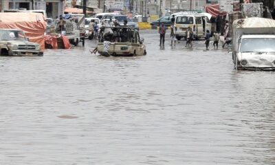
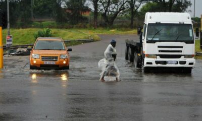
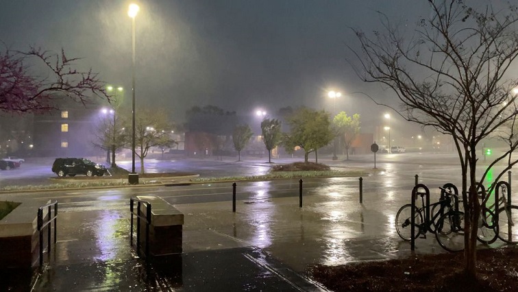
South Africans barely had time to dry out their shoes after last weekend’s intense downpours before meteorologists issued the next warning: more extreme weather is lining up, and parts of the country could face another round of heavy storms before the week is out.
From flooded bridges in Boksburg to uprooted trees in Roodepoort and an overturned bakkie in Pretoria’s Apies River, emergency teams have been stretched thin. For many residents in Gauteng and the Free State, the sound of thunder has practically become the soundtrack of spring.
And according to forecasters, we’re not done yet.
A Weekend of Weather Chaos
The past weekend brought the kind of numbers that make even seasoned weather watchers blink:
-
170mm of rain soaked parts of the northern Free State between Friday and Sunday morning.
-
Sections of the Vaal measured 72mm in a single spell.
Vox Weather’s Michelle Cordier explained that a low-pressure system near Namibia set the stage for the weekend’s chaos the type of system that, once it digs in, can produce “days-long rainfall that just doesn’t let up.”
Looking ahead, Cordier warns that some weather models show over 100mm possible this weekend in parts of Gauteng, the Highveld and northern KwaZulu-Natal, although she stresses that rainfall will vary widely.
Still, 50mm or more is likely in the eastern North West, Limpopo bushveld, Mpumalanga highveld, Gauteng, northern Free State and central to northern KwaZulu-Natal. Limpopo, she noted, will remain particularly wet into early next week.
Social media, naturally, has been buzzing.
From videos of stormwater swallowing cars in Soweto to memes joking about Noah’s Ark needing a Joburg branch, the public mood is anxious but determined, classic South African humour in the face of chaos.
Thunderstorms Lining Up for the Week
Weather enthusiast Juandre Vorster, known online as The Weather Hooligan, says this week will be marked by moderate storms, peaking on Thursday and Friday when Gauteng could see severe thunderstorms and a level 2 weather warning.
Meanwhile, SA Weather Service forecaster Lehlohonolo Thobela says a 30% chance of showers and thundershowers remains for Gauteng, the Free State and KwaZulu-Natal heading into Tuesday, with slightly warmer conditions expected midweek.
But the warmth doesn’t mean the rain is over.
The Wettest October in Recent Memory
If you feel like this spring has been unusually soggy, you’re not imagining things.
Last week, the SA Weather Service confirmed that October 2024 went down as one of the wettest in recent history for many parts of South Africa.
A few stand-out stats:
-
Lichtenburg, North West:
Average October rainfall: 50mm
Last month: 243mm -
Thabazimbi, Limpopo:
Average October: 26mm
Last month: 101mm -
Barberton, Mpumalanga:
Average October: 28mm
Last month: 120mm
Some stations recorded four times their normal rainfall, and several logged their wettest October in 31 years.
But the rainfall wasn’t evenly spread.
While the central and eastern parts of the country were drenched, the western and northwestern regions remained relatively dry, with many areas staying under 50mm for the month.
Why This Matters and What’s Coming Next
South Africa’s summer rainfall season officially kicks off in October, but this year the season hit the accelerator early. With climate patterns shifting globally, South Africa is experiencing more frequent bursts of intense rainfall, often arriving in shorter, more destructive windows.
The forecast for the remainder of summer shows an enhanced likelihood of above-average rainfall across the central and eastern regions a trend that could mean fuller dams, greener landscapes, but also a higher risk of flooding, infrastructure strain and crop damage.
For residents in weather-prone areas, the message is clear:
Prepare early, stay alert, and keep emergency numbers close.
Because if October was the opening act, summer may still have bigger storms waiting in the wings.
{Source: The South African}
Follow Joburg ETC on Facebook, Twitter , TikTok and Instagram
For more News in Johannesburg, visit joburgetc.com