News
South Africa’s Flood Hotspots: The Communities Bracing For A Hard La Niña Summer
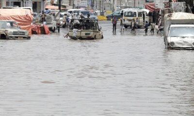
As the first heavy rains of the season sweep across the country, South Africa is once again asking a familiar question: why do the same communities bear the brunt of flooding year after year? This week, the national Department of Human Settlements mapped out the latest flood hotspot areas, highlighting regions where repeated storms and inadequate infrastructure continue to devastate homes, families and livelihoods.
The announcement comes as meteorologists warn that the ongoing La Niña cycle is about to intensify, bringing heavier, longer-lasting rainfall from now until March 2026.
And across the country, disaster teams are already seeing the early signs.
Western Cape Tops The List Of High-Risk Areas
According to the department, the Western Cape has the highest concentration of flooding hotspots. Places like Khayelitsha, Dunoon, Philippi, Langa, Wallacedene, Mfuleni, Gugulethu and Joe Slovo require repeated emergency interventions every year.
These communities share the same familiar challenges: high-density informal settlements built on low-lying or waterlogged land, ageing drainage systems and limited long-term infrastructure investment.
On social media, Cape Town residents say they’re not surprised.
“Every winter, it’s the same photos, same flooded shacks, same mop-up promises,” wrote one user on X. “Where’s the long-term plan?”
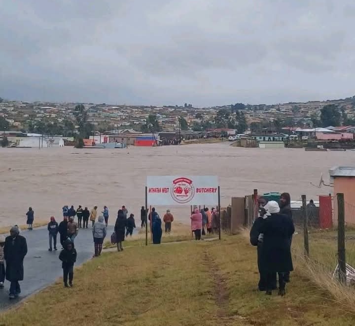
Eastern Cape’s Coastal Settlements Stay In Harm’s Way
In the Eastern Cape, hotspots include Duncan Village, Nompumelelo, Umtata, Ingquza Hill and Bizana. But Port St Johns stands out as one of the most persistently affected places in the province.
Its location along a vulnerable coastline and river banks makes it extremely prone to storm surges and flash floods. Local community groups say relocation has been discussed for years but never implemented.
KZN Reeling From A Weekend Of Tragedy
KwaZulu-Natal continues to battle heartbreak after severe storms in Hlanovu and UMzimkhulu left families searching for their loved ones. Areas like Kennedy Road, uMlazi and Masinenge remain extremely vulnerable.
KZN residents online expressed frustration at the recurring loss of life.
“How many times must people drown before disaster prevention becomes the priority?” asked a Durban-based community activist on Facebook.
Gauteng Prepares For Jukskei Flood Risks
Even landlocked Gauteng isn’t spared. The Jukskei River corridor, which runs through several informal settlements, is notorious for rising quickly after heavy rainfall.
Provincial disaster head Tshepo Motlhale says the province is using artificial intelligence to monitor risk zones and operates a mobile reporting app to speed up rescue responses. Swift-water rescue teams have also been deployed across municipalities ahead of the La Niña peak.
Limpopo, North West, Northern Cape And Mpumalanga Already Feeling The Strain
Disaster managers reported:
-
Limpopo: Capricorn, Mopani and Sekhukhune districts facing severe thunderstorms, while Vhembe and Waterberg prepare for flood surges.
-
Mpumalanga: 127 homes damaged since summer began. The Dr JS Moroka municipality alone saw 87 houses affected this week.
-
Northern Cape: Despite its dry climate, towns near the Vaal and Orange Rivers face flooding when dam gates upstream are opened.
-
North West: Flash-flood risk mapping, fire-safety audits and summer storm preparation are underway.
Why Flood Damage Keeps Getting Worse
Across provinces, one theme repeated itself: failing infrastructure.
Blocked stormwater drains, illegal dumping, outdated drainage systems and unmaintained roads all increase the severity of flooding, particularly in densely populated townships and informal settlements.
Motlhale pointed out that clearing drains is part of Gauteng’s CBD revitalisation plan, but communities say temporary fixes aren’t enough.
A 48-Hour Emergency Response Promise
National officials have promised to be on the ground within 48 hours of any reported disaster. Forty-eight volunteers have even given up their festive holidays to serve as liaison officers in high-risk communities.
Engineers from the Housing Development Agency have also been deployed to speed up assessments and the construction of temporary residential units.
But temporary residential units are not a permanent solution.
Why Are Communities Still Stuck In Flood Zones?
During a parliamentary discussion, MK Party MP Saira Abader raised a painful point: why are the same families forced to rebuild in the same dangerous places year after year?
Her concerns echo what many South Africans say online:
“Hotspot mapping doesn’t save lives if people are left where they are,” one commenter wrote under a news report.
Officials admitted that identifying hotspots has not translated into permanent relocation or upgrades. Instead, emergency responses continue to cycle through the same communities every rainy season.
A New Plan To Break The Cycle
There may be hope. The department confirmed a new pilot project in the Eastern Cape, where permanent housing will be built immediately after disasters instead of relying solely on temporary shelters. If successful, it could expand nationwide next year.
For families who have rebuilt their lives more than once, the possibility of a safe, permanent home cannot come soon enough.
Communities Stay On High Alert
As summer deepens and rains intensify, emergency teams remain on standby across all hotspot areas. The coming months will test both the country’s infrastructure and its commitment to protecting the communities most at risk.
For now, residents brace themselves, hoping this will be the year a meaningful, long-term solution finally begins.
{Source:The Citizen}
Follow Joburg ETC on Facebook, Twitter , TikTok and Instagram
For more News in Johannesburg, visit joburgetc.com