News
Floodwaters shut Pafuri and Giriyondo border crossings in Kruger National Park
Heavy rains in Limpopo have triggered travel disruptions along the northern border, forcing authorities to temporarily close two key crossings between South Africa and Mozambique.
The Border Management Authority confirmed that the Pafuri and Giriyondo ports of entry have been shut due to flooding at the border posts and surrounding areas. The precautionary decision comes as rivers continue to swell following several days of intense rainfall across parts of the province.
For travellers heading through Kruger National Park or planning cross-border trips into Mozambique, the closure could mean adjusting routes or postponing travel plans.
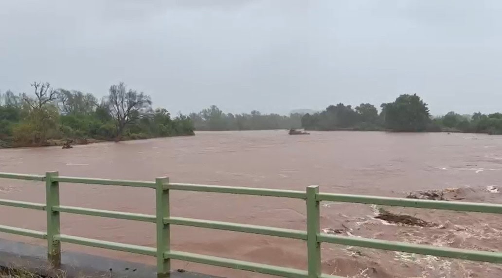
Rising rivers trigger safety concerns
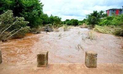
According to the Border Management Authority, floodwaters have risen significantly around the Pafuri Port of Entry, which sits in the far northern region of Kruger National Park.
The nearby Luvuvhu River bridge has seen water levels increase noticeably, with rangers reporting that the river rose by roughly half a metre compared with the previous day. With the river running close to the border facility, officials flagged a potential safety risk for travellers, staff, and infrastructure.
Additional pressure is coming from other rivers in the area. Authorities reported that the Klein Letaba and Middlevlei rivers are overflowing, while the Letaba bridge is nearing full capacity due to continued inflows caused by the heavy rainfall.
Access to Pafuri Gate also affected
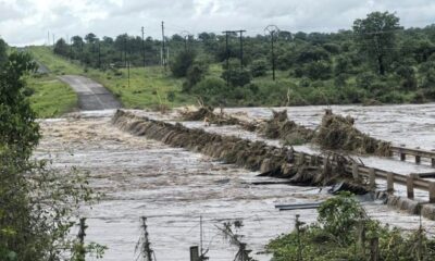
Flooding has also forced the closure of Pafuri Gate, which serves as the main access route to the Pafuri Port of Entry.
The gate lies about 30 kilometres from the border facility, but rising water levels in the surrounding roads made the route unsafe for vehicles. As a result, travellers hoping to reach that part of the park have been advised to use Punda Maria Gate, located about 65 kilometres away, which remains open and accessible.
A key crossing in a unique cross-border park
The Giriyondo crossing carries its own significance. It forms part of the Great Limpopo Transfrontier Park, a conservation area that links protected land across South Africa, Mozambique, and Zimbabwe.
The border post has long been popular with travellers exploring Kruger and continuing their journey into Mozambique’s wildlife reserves. Its temporary closure, therefore, affects not just cross-border traffic but also regional tourism routes within the transfrontier park.
Staff evacuated as precaution
Authorities moved quickly to protect personnel and equipment stationed at the affected border posts.
All Border Management Authority staff, Port Management Committee members, and operational vehicles were evacuated as a precaution while floodwaters continued to rise. Officials confirmed that there have been no injuries and no reported damage to infrastructure so far.
The decision to suspend operations was taken purely as a safety measure while the situation stabilises.
Limpopo authorities remain on high alert
Provincial authorities are continuing to monitor the broader flooding situation across Limpopo, where heavy rains have also damaged road infrastructure in some areas.
For now, officials say the closures will remain in place until water levels drop and conditions are considered safe again.
The Border Management Authority says it is working closely with park officials and other relevant authorities to monitor developments on the ground. Once the floodwaters subside and roads reopen, operations at the affected ports of entry are expected to resume.
For travellers, the message is simple: check routes carefully and stay updated before heading north.
Follow Joburg ETC on Facebook, Twitter, TikT
For more News in Johannesburg, visit joburgetc.com
Source: The Citizen
Featured Image: Maroela Media