Weather
Severe storms set to hit South Africa as damaging winds and hail loom
A volatile Tuesday ahead for much of the country
South Africans woke up to a mixed bag of weather on Tuesdaybut don’t let the scattered sunshine fool you. As the day unfolds, conditions are expected to turn dramatic, with thunderstorms building across large parts of the country and bringing the potential for damage, disruption, and sudden downpours.
According to the South African Weather Service, a Yellow Level 2 warning has been issued for severe thunderstorms affecting key regions, including KwaZulu-Natal, the Mpumalanga escarpment, central and eastern Free State, and the southern parts of North West.
Where the worst of the weather will hit
Central and eastern regions on high alert
The biggest concern lies over the central and eastern interior, where storms are expected to intensify through the afternoon. These areas could see heavy rain, large hail, strong winds, and frequent lightningall within a short space of time.
In the Free State, conditions are particularly unstable, with an 80% chance of rain expected. Bloemfontein and surrounding areas are likely to bear the brunt, with widespread showers and thunderstorms forecast.
Gauteng and parts of North West won’t be spared either. Johannesburg and Pretoria can expect cloudy skies, cooler temperatures, and a 60% chance of stormstypical of those late-summer days where the weather turns quickly.
Coastal and eastern provinces brace for humidity-fuelled storms
KwaZulu-Natal will see a mix of scattered showers and thunderstorms, especially in the north and west. The humid air along the coast is expected to fuel storm development, although coastal areas may experience slightly less intense activity.
Mpumalanga sits in a similar position, with rain chances between 30% and 60%, particularly along the escarpment where storms tend to build more aggressively.
Limpopo, on the other hand, remains mostly warm, with isolated showers expected in central and eastern areas while the far north stays dry.
A calmer picture in the westmostly
The Northern Cape will experience a relatively mild day compared to the rest of the country. While central and eastern regions may see isolated thunderstorms, the western parts are expected to remain dry, with shifting coastal winds later in the day.
In the Western Cape, including Cape Town, the morning starts off foggy before clearing into partly cloudy skies. There’s a slight chance of rain developing in the south-west by evening, but the standout feature here is a very high UV indexso even with clouds around, sun protection remains essential.
Eastern Cape sees mixed conditions
The Eastern Cape will experience a bit of everythingmorning fog in some areas, followed by increasing cloud cover. The western half has a chance of evening thunderstorms in the north, while the eastern half will see more consistent showers developing throughout the day.
Social media already buzzing
As always, South Africans have taken to platforms like X (formerly Twitter) to share weather updates, with videos of darkening skies, sudden downpours, and lightning already making the rounds by midday. For many, it’s a familiar scenethis time of year often brings unpredictable weather swings that can turn a normal day into a stormy one within hours.
Why this kind of weather isn’t unusual
This pattern isn’t entirely out of the ordinary. South Africa’s late summer and early autumn months are known for high-energy weather systems, especially over the interior. Warm, moist air from the Indian Ocean collides with cooler air inland, creating the perfect conditions for thunderstorms to develop rapidly.
However, what makes today notable is the widespread nature of the activity and the potential severityparticularly with the risk of hail and damaging winds, which can affect homes, vehicles, and infrastructure.
What you should watch out for
Residents in affected areas are advised to stay alert, especially during the late afternoon and evening when storms are expected to peak.
Keep an eye out for:
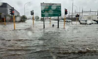
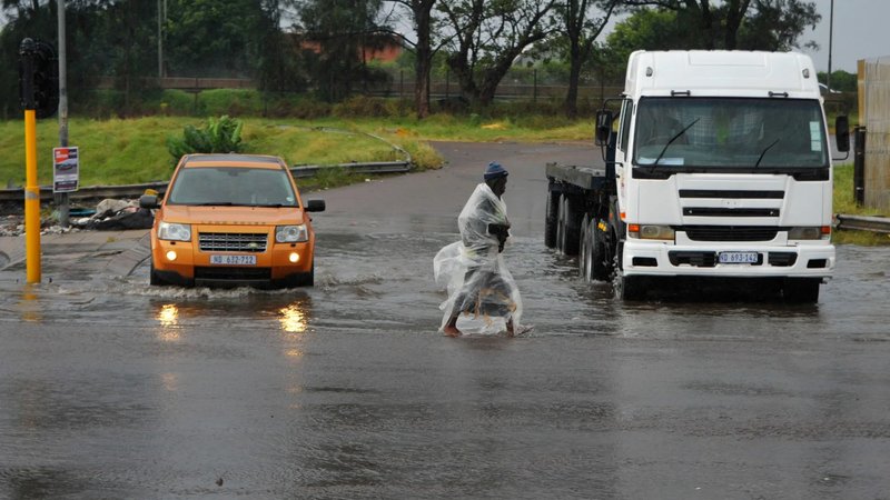
- Sudden heavy rainfall leading to localised flooding
- Strong winds that could damage roofs or uproot trees
- Large hail that can dent cars and break windows
- Lightning strikes, particularly in open areas
A day to stay weather-aware
Tuesday’s forecast is a reminder of just how quickly conditions can change across South Africa. Whether you’re commuting in Gauteng, working in the Free State, or heading out along the KZN coast, it’s worth keeping an umbrellaand a bit of cautionclose at hand.
{Source: IOL}
Follow Joburg ETC on Facebook, Twitter , TikTok and Instagram
For more News in Johannesburg, visit joburgetc.com